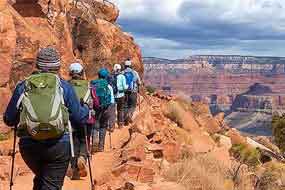
If you are looking for the most views per mile on one of Grand Canyon’s maintained corridor trails, the South Kaibab Trail is difficult to beat. Instead of descending through a narrow side canyon, it follows an exposed ridgeline, opening broad inner-canyon views almost immediately below the South Rim.
That exposure is both the trail’s greatest attraction and its greatest hazard. There is very little shade and no drinking water anywhere along the trail. During summer, the open terrain can become dangerously hot. In winter and early spring, the upper trail can still develop hard, hazardous ice despite receiving more sun than many shaded canyon routes.
Most day hikers should turn around at Ooh Aah Point or Cedar Ridge. Strong, experienced hikers may consider Skeleton Point in suitable weather, but the National Park Service advises against continuing below Skeleton Point as a day hike. The descent can feel surprisingly easy; the steep climb back to the rim is the real test.
There Is No Water Along the South Kaibab Trail
Carry all the water needed for the complete hike. Do not depend on finding water below the trailhead, and do not divide one group water supply among several hikers.
Water systems at Grand Canyon can be interrupted by pipeline problems. Check current National Park Service hiking updates before leaving the rim.
| South Kaibab Trail at a Glance | What to Know |
|---|---|
| Trailhead elevation | 7,260 feet |
| Trail condition | Maintained dirt trail; steep and well defined |
| Shade | Very limited |
| Water | No drinking water anywhere along the trail |
| Best short hike | Ooh Aah Point, 1.8 miles roundtrip |
| Best half-day hike | Cedar Ridge, 3 miles roundtrip |
| Maximum recommended day-hike destination | Skeleton Point |
| Restrooms | Cedar Ridge and the Tipoff |
| Private vehicle access | Not permitted at the trailhead |
| Day-hiking permit | Not required for an ordinary day hike |
| Overnight permit | Required for backcountry camping |
South Kaibab Trail Distances and Turnaround Points
The right turnaround point depends on temperature, daylight, hiking experience and how everyone in the group feels during the descent. Every downhill step must be climbed on the return.
The National Park Service recommends allowing approximately twice as much time to hike back up as it took to descend. Most first-time Grand Canyon hikers climb at about one mile per hour.
| Destination | One-Way Distance | Roundtrip Distance | Elevation | Best For |
|---|---|---|---|---|
| Ooh Aah Point | 0.9 mile | 1.8 miles | 6,660 feet | Short scenic hike |
| Cedar Ridge | 1.5 miles | 3 miles | 6,120 feet | Prepared first-time canyon hikers |
| Skeleton Point | 3 miles | 6 miles | 5,200 feet | Strong, experienced day hikers |
| The Tipoff | Approximately 4.4 miles | Approximately 8.8 miles | Approximately 4,010 feet | Backcountry and overnight itineraries |
| Bright Angel Campground | 6.8 miles | 13.6 miles | Approximately 2,480 feet | Permitted overnight trips |
Ooh Aah Point
Distance: 0.9 mile one way; 1.8 miles roundtrip
Elevation loss: Approximately 600 feet
Typical commitment: About 1 to 2 hours
Best for: First-time visitors and short hikes below the rim
Ooh Aah Point is the first major panoramic viewpoint on the South Kaibab Trail. The upper switchbacks descend beside the canyon wall before the trail reaches an exposed ridge and opens to a wide view.
The point is not a developed overlook. There is no sign identifying the exact location, no drinking water, no restroom and little shade. It is a widening along the trail where the view expands dramatically.
This is the most practical South Kaibab destination for many visitors. It provides a true below-the-rim experience without committing hikers to the longer climb from Cedar Ridge or Skeleton Point.
The return gains approximately 600 feet in less than one mile. Anyone already feeling overheated, dizzy, weak or unusually tired should rest, eat and begin climbing rather than continuing downhill.
Cedar Ridge
Distance: 1.5 miles one way; 3 miles roundtrip
Elevation loss: Approximately 1,140 feet
Typical commitment: About 2 to 4 hours
Best for: A longer scenic hike in mild conditions
Cedar Ridge is a broad saddle with expansive views in several directions. It offers more room to rest than Ooh Aah Point and has composting toilets, but it does not have drinking water.
The National Park Service identifies Cedar Ridge as a good turnaround point for first-time canyon hikers, casual hikers and late starters. It should be treated as the maximum summer day-hike destination rather than the beginning of a longer afternoon adventure.
Mules use the hitching rail and surrounding trail. Keep food secured, give the animals space and immediately follow instructions from wranglers.
Skeleton Point
Distance: 3 miles one way; 6 miles roundtrip
Elevation loss: Approximately 2,060 feet
Typical commitment: About 4 to 6 hours or longer
Best for: Strong, experienced hikers in suitable conditions
Beyond Cedar Ridge, the trail crosses below O’Neill Butte and continues along the exposed ridge toward Skeleton Point. The first views of the Colorado River appear near this section of trail.
Skeleton Point is not appropriate for everyone who comfortably reaches Cedar Ridge. The return requires climbing more than 2,000 feet without water and with very little shade.
The National Park Service identifies Skeleton Point as the maximum day-hike turnaround. Hikers should not continue below it on a standard day hike.
Turn around earlier when heat, water consumption, pace, fatigue or approaching weather makes the original plan unrealistic. The canyon does not issue medals for stubbornness.
The Tipoff
Distance: Approximately 4.4 miles one way
Roundtrip distance: Approximately 8.8 miles
Facilities: Composting toilets and an emergency phone
The Tipoff is near the junction of the South Kaibab Trail and Tonto Trail. From here, the South Kaibab begins its final steep descent through the inner gorge toward the Colorado River.
This is not a routine day-hiking destination. A roundtrip hike involves nearly nine miles of travel and more than 3,000 feet of climbing on the return, with no drinking water along the route.
Travel below Skeleton Point should be reserved for properly planned backcountry itineraries and experienced hikers following current ranger guidance.
Colorado River and Black Bridge
The South Kaibab Trail descends from the Tipoff through steep switchbacks toward the Colorado River. Hikers pass through a short tunnel before crossing Black Bridge to the north side of the river.
Black Bridge connects the South Kaibab Trail with Bright Angel Campground, Phantom Ranch and the lower North Kaibab Trail. It is also used for mule crossings.
Bright Angel Campground is 6.8 miles from the South Kaibab Trailhead. Reaching it requires descending approximately 4,700 feet from the South Rim.
The route is shorter than Bright Angel Trail, but it is not easier. It has little shade, no trail water and a sustained climb back to the rim.
Bright Angel Campground and Phantom Ranch
Bright Angel Campground is located north of the Colorado River near Bright Angel Creek. Phantom Ranch is a short walk beyond the campground.
A backcountry permit is required to camp overnight. Phantom Ranch lodging and meals require separate advance reservations. Arriving at the river does not guarantee access to a campsite, cabin or prepared food.
Water is normally available in the Bright Angel Campground and Phantom Ranch area, but pipeline failures can interrupt service. Overnight hikers should verify current conditions and carry a reliable water-treatment method.
Why Was the South Kaibab Trail Built?
The South Kaibab Trail is more than a scenic hiking route. Its construction reflects an early dispute over public access to the inner canyon.
Ralph Cameron and his partners widened what became Bright Angel Trail during the mining era. Cameron later charged visitors a toll to use that route. Coconino County took control of Bright Angel Trail in 1912 after Cameron’s legal right to operate it as a toll road expired.
Legal disputes between the county and the National Park Service continued after Grand Canyon became a national park in 1919. In response, the National Park Service constructed a new publicly managed route from near Yaki Point toward the Colorado River.
Construction of the South Kaibab Trail began in 1924 and was completed in 1925. It provided toll-free access to Phantom Ranch and became one of the principal trails in Grand Canyon’s maintained corridor system.
Access, Conditions and Hiking Safety
Getting to the Trailhead
Private vehicles are not allowed on the road to South Kaibab Trailhead. Hikers must use the park’s designated transportation system to reach it.
Check current National Park Service transportation information before the hike because routes, stops and departure times can change seasonally.
Check current trailhead transportation information »
Summer Heat
The South Kaibab Trail has very little shade. Summer temperatures in the inner canyon routinely exceed 100°F, and the trail can become substantially hotter than the South Rim.
During hot weather:
- Begin before sunrise when practical.
- Avoid strenuous hiking between 10 a.m. and 4 p.m.
- Carry all water required for the complete hike.
- Balance water with salty food and calories.
- Rest before becoming exhausted.
- Turn around earlier than planned when conditions deteriorate.
Heat-related rescues and deaths occur at Grand Canyon. Rescue assistance may be delayed by weather, limited staff, concurrent emergencies or unsafe flying conditions.
Water, Food and Electrolytes
Every hiker should carry an individual water supply. Do not place all group water in one backpack, and do not assume that someone else will have enough to share.
Drink according to thirst and eat regularly. Consuming excessive plain water without enough salt and calories can cause hyponatremia, a dangerous electrolyte imbalance.
Useful trail foods include:
- Salty crackers or pretzels
- Sandwiches
- Trail mix
- Energy bars
- Electrolyte drinks or mixes
- Foods that remain edible in heat
Winter Ice and Snow
The ridgeline receives substantial sun, which can keep much of the trail relatively free of snow and ice. However, the steep upper section can become dangerously icy in winter and early spring.
Hard ice can remain even when nearby rim sidewalks look clear. Over-the-shoe traction devices are highly recommended when icy conditions are possible.
Do not descend across ice unless everyone in the group has the equipment and ability to climb it safely on the return.
Thunderstorms
From July through September, monsoon storms can bring lightning, heavy rain, falling rocks and sudden temperature changes. The exposed ridgeline offers little shelter.
Check the forecast before hiking. Seek safer terrain immediately when thunder is heard, and do not remain on exposed points for photographs.
Mules on the Trail
Mules regularly use the South Kaibab Trail. When a mule train approaches:
- Step off the trail on the uphill side, away from the edge.
- Follow the wrangler’s instructions.
- Remain quiet and completely still.
- Wait until the final mule is at least 50 feet beyond you before returning to the trail.
Never stand on the downhill side of the trail or make sudden movements around stock.
Trail Etiquette
- Give uphill hikers the right of way.
- Do not cut switchbacks.
- Keep the group together.
- Allow the slowest member to set the pace.
- Pack out all trash and food scraps.
- Use toilets where provided.
- Do not feed wildlife.
- Do not bring pets below the rim.
Permits and Camping
A permit is not required for an ordinary day hike on the South Kaibab Trail.
A backcountry permit is required for overnight camping below the rim. There are no designated campsites along the upper day-hiking section between the trailhead and Skeleton Point.
Permitted camping is available at designated backcountry campgrounds, including Bright Angel Campground near the Colorado River.
South Kaibab Trail vs. Bright Angel Trail
| South Kaibab Trail | Bright Angel Trail |
|---|---|
| Follows an exposed ridgeline | Descends through a side canyon and fault |
| Wide views begin quickly | Views unfold more gradually |
| No water along the trail | Water may be available at designated locations |
| Very little shade | More shade and sheltered rest areas |
| Private vehicles cannot reach the trailhead | Trailhead is located in Grand Canyon Village |
| 6.8 miles to Bright Angel Campground | 9.3 miles to Bright Angel Campground |
| Best short destination: Ooh Aah Point | Best short destination: Mile-and-a-Half Resthouse |
| Best for immediate panoramic views | Generally preferred for climbing from the river |
For a short scenic hike, South Kaibab provides wider views sooner. For a longer hike or an ascent from the river, Bright Angel is generally more practical because it offers more shade, rest areas and potential water access.
Compare the Bright Angel Trail »
Plan the Right South Kaibab Day Hike
Short Hike to Ooh Aah Point
Roundtrip distance: 1.8 miles
Best for: First-time visitors, limited schedules and cooler morning hikes
Start early, descend to the first wide ridgeline view and return before heat or fatigue develops. Although short, this hike still requires climbing approximately 600 feet back to the rim.
Half-Day Hike to Cedar Ridge
Roundtrip distance: 3 miles
Best for: Prepared hikers in mild weather
Cedar Ridge provides a broader resting area, toilets and panoramic views. It is the best longer day-hike destination for many visitors and the maximum recommended summer turnaround.
Strenuous Hike to Skeleton Point
Roundtrip distance: 6 miles
Best for: Experienced hikers with an early start and suitable conditions
Skeleton Point provides the first view of the Colorado River but requires more than 2,000 feet of climbing on the return. Do not attempt it during dangerous heat, winter ice, approaching thunderstorms or with a late start.
What to Bring
- All drinking water needed for the complete hike
- Salty food and substantial snacks
- Supportive hiking footwear
- Sun hat, sunscreen and sunglasses
- Warm and weatherproof layers
- A headlamp, even for planned daylight hikes
- Downloaded trail and park information
- Traction devices when ice is possible
- Basic first-aid and blister supplies
Before You Start
- Check current trail closures and alerts.
- Review the rim and inner-canyon forecasts.
- Tell someone where you are hiking and when to expect you back.
- Choose a firm turnaround time as well as a destination.
- Confirm that every group member has water, food and appropriate footwear.
- Turn around when the weakest hiker needs to stop.
Check current NPS hiking alerts and conditions »
South Kaibab Trail FAQs
How long is the South Kaibab Trail?
The South Kaibab Trail is 6.8 miles from the South Rim trailhead to Bright Angel Campground near the Colorado River. Most day hikers complete only the upper portion.
How far is Ooh Aah Point?
Ooh Aah Point is 0.9 mile from the trailhead, making the hike 1.8 miles roundtrip with approximately 600 feet of elevation change.
How far is Cedar Ridge?
Cedar Ridge is 1.5 miles from the trailhead and three miles roundtrip. It sits approximately 1,140 feet below the South Rim.
How far is Skeleton Point?
Skeleton Point is three miles from the trailhead and six miles roundtrip. The return requires climbing approximately 2,060 feet.
Is there water on the South Kaibab Trail?
No. There is no drinking water anywhere along the trail. Every hiker must carry enough water for the complete trip.
Can you drive to the South Kaibab Trailhead?
No. Private vehicles are not allowed on the trailhead road. Visitors must use the park’s designated transportation system.
Do you need a permit to hike South Kaibab Trail?
A permit is not required for an ordinary day hike. A backcountry permit is required for overnight camping below the rim.
Which is easier, South Kaibab or Bright Angel?
Both trails are strenuous. South Kaibab is shorter but has almost no shade and no water. Bright Angel is longer but offers more shade, rest areas and potential water access.
Can you hike to the river and back in one day?
The National Park Service does not recommend hiking from the South Rim to the Colorado River and back in one day.
Can dogs hike South Kaibab Trail?
No. Pets are not permitted on trails below the Grand Canyon rim. Qualifying service animals are subject to separate National Park Service requirements.
What is the best turnaround point?
Ooh Aah Point is best for many first-time visitors. Cedar Ridge is appropriate for prepared hikers in suitable conditions. Skeleton Point is the maximum recommended day-hike destination.
Related Grand Canyon Hiking Guides
- Grand Canyon Hiking Guide
- Bright Angel Trail Hiking Guide
- Grand Canyon Rim Trail Guide
- Grand Canyon Village Visitor Guide